|
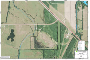
Elbow Slough Wildlife Management Area
|
|
|
||||||
|
Elbow Slough is a small tract consisting of 160 acres located in southeastern Rapides parish near the
intersection of U.S. Hwy 1 and LA Hwy 3170. It was formerly cropland.The area lies within the Red River floodplain.Terrain
is flat with heavy clay soils that are poorly drained. Approximately 100 acres were planted to native hardwood species in
the early 1990's.
Click Here To Read More... |
||||||||