|
Sherburne Wildlife Management Area
|
|
|
|
||||||
|
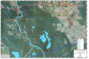
Sherburne Wildlife Management Area, located in the Morganza Flood way system of the Atchafalaya Basin,
is situated in the lower and upper portions of Pointe Coupee, St. Martin, and Iberville Parishes respectively, between the
Atchafalaya River and the East Protection Guide Levee. The Sherburne WMA, Atchafalaya National Wildlife Refuge and the U.S.
Army Corps of Engineers lands combine to form a 44,000 acre tract. The Louisiana Department of Wildlife and Fisheries owns
11,780 acres, the U.S. Fish and Wildlife Service owns 15,220 acres and the remaining 17,000 acres is owned by the U.S. Army
Corps of Engineers. The area is managed as one unit by the Louisiana Department of Wildlife and Fisheries.
Click Here To Read More... |
||||||||